Showing posts with label Franklin. Show all posts

May 9 - First Cartoon in Franklin's Newspaper

   Posted on May 9, 2022

This is an update of my post published on May 9, 2011:


What is a cartoon? I bet you already know that answer...
                ….Or do you?

The word cartoon comes from Italian and Dutch words for heavy paper. A cartoon used to be a preparatory drawing made (on heavy paper) before starting a tapestry, fresco, stained glass window, or painting.

The term evolved to mean humorous illustrations printed in newspapers and magazines. (We more commonly call them comics now.)


The word cartoon is most used these days to mean animated television shows.

Many early newspaper cartoons were not meant to be funny. Instead, they were meant to make a point—often a political point. We call these sorts of illustrations political cartoons. That's the case with this first American cartoon, published on this day in 1754 in Benjamin Franklin's newspaper The Pennsylvania Gazette. It showed a snake that was divided into eight pieces, and the caption read “JOIN, or DIE.” Can you imagine what the cartoon meant?

Hint: notice the initials next to each snake “bit.”

Second hint: Remember, there was no such thing as the United States in 1754. Instead, there was a series of British colonies up and down the coast of North America.
.
.
.
I think Franklin was warning people that the British colonies should unite together under one government, or they will not be strong enough to survive. The eight sections of the snake were (in order from the head to the tail) New England, New York, New Jersey, Pennsylvania, Maryland, Virginia, North Carolina, and South Carolina. Notice that there were four colonies (Massachusetts, Connecticut, Rhode Island, and New Hampshire) in New England, and Franklin left Delaware and Georgia out of the cartoon! Apparently one of these being awfully small and one of them a new colony, Franklin didn't consider that they would be much help with defense.


A later (1775) version of Franklin's Join Or Die cartoon
appeared with Georgia included...


At the time that Franklin ran the cartoon in his newspaper, the colonies were in danger from French colonists to the north and from Indians. Franklin had proposed a union under the Albany Plan—and this cartoon was a quick visual argument for why others should go along with his plan. The cut-up snake became quite popular and was re-used and re-drawn many times. As a matter of fact, it's still current: A punk rock group named Sons of Liberty used the picture and caption for an album called “Join or Die,” and The Late Late Show host Craig Ferguson has the cartoon tattooed on the inside of one of his forearms!


Check out some more historical political cartoons at Harp Week, and current cartoons at Daryl Cagle's website


May 2 - You Go, Gulf Stream!

   Posted on May 2, 2022


This is an update of my post published on May 2, 2011:

Back in the old days, when there were no such things as telephones or computers, let alone cell phones and 4-G and the internet and WiFi, there were these things called letters. People would write on this stuff called paper, and they would get someone to physically carry their letters from one place to another. Sounds pretty slow, right?

Well, in the 1700s, Benjamin Franklin noticed that mail coming to America from Europe was even slower than the mail going from America to Europe. Boats crossing the Atlantic Ocean could travel westward at least a couple of weeks faster than boats traveling eastward.


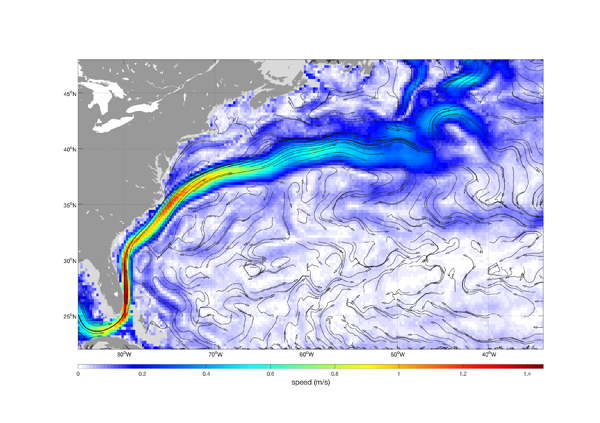
An ocean current that acts like a river on the ocean is responsible for this extra speed. Although American whalers and some other seagoing people knew about this current by the 1700s, the knowledge wasn't as widespread as I'd imagined it would be. American whaling captain Timothy Folger told his cousin, Benjamin Franklin, that American whalers had explained to English sea captains how to use the current for maximum speed—but, he went on to say, the Brits had ignored the advice. Folger said the English captains were a bit snobbish and thought themselves “too wise to be counseled by simple American fishermen.” 

Benjamin Franklin was intrigued. He began a scientific study of the current in the Atlantic, measuring the temperatures of the water two or three times a day on his voyage home from England, and noting the water color and any seaweed he saw. Some sources claim that he completed his study on this day in 1775. 

Franklin and Folger drew charts to show the location of the current. Studies today, including satellite data, show that these early charts were remarkably accurate.


(By the way, did you know that we use the word charts for water in the same way we use the word maps for land?) 

Franklin explained the cause of the current—the accumulation of water on the eastern coast of America due to the constant trade winds. (Basically, he was right.)


Those yellow lines heading south and west represent the
North Trade Winds, and the blue lines heading north
and east represent the Westerlies. The global winds
affect the water currents of the ocean.

And Franklin named the current he discovered "the Gulf Stream." (We still use the name today.)

Still Important

Even though speed-of-light communication via electronic transmission and satellites has left the old moving-pieces-of-paper kind of communication behind in the dust, we still trade goods and catch fish and even travel by ship--and we still want to go with the current when traveling eastward across the Atlantic Ocean, and to avoid going against the current when traveling westward.

But there is another reason the Gulf Stream is so important: climate.

You see, the Gulf Stream is made up of warm water traveling up from the tropics and over the ocean to the British Isles. As it moves into colder areas of the world, the water slowly cools, of course—but it is still warm enough, when it reaches Europe, to keep England warmer than it would be without the Gulf Stream.


London and Cambridge, show here in the spring
(photo above and two photos below)
are roughly the same latitude as...


...Lake Baikal in Russia, also shown in the spring
(photo above and two photos below).
Yeah, you're looking at snow and ice!


Grab a globe and use it to check the latitude of England—and then compare that latitude to areas in Canada and Russia that are the same latitude. A little digging will show you that England's climate is milder than it ought to be, if latitude were the only factor:

  • London's average temperatures range from 45 to 58 degrees F (7 to 14 degrees C).
  • At around the same latitude, parts of Siberia enjoy temperatures from 28 to 44 degrees F (-2 to 7 degrees C). Much colder!
  • And at about the same latitude, the southern part of Labrador in Canada is classified as sub-arctic. The average temperatures range from -18 to 65 degrees F (-28 to 18 degrees C), and there is snow cover for months every winter.


Here is another chart from the pen of Benjamin
Franklin. It shows that he realized that the Gulf
Stream is actually a loop.


Also on this date:


Dos de Mayo in Spain


Anniversary of the first (modern) legend of Nessie


Plan ahead:

August 23 - The State of Franklin Established (Wait! "The State of Franklin???)

 Posted on August 23, 2021


This is an update of my post published August 23, 2010:


Did you know that part of the land that now makes up Tennessee was once the state of Franklin?

The pioneers who had settled this land, which originally belonged to North Carolina but had been given to Congress and then taken back again, became upset with the government of North Carolina and decided to set up their own independent state. On this date in 1784, representatives of four North Carolina counties declared their lands independent of North Carolina.


This historic building served as the Capitol of the State
of Franklin during the four years of its existence.

Note, however, that as far as North Carolina was concerned,
and as far as the Continental Congress was concerned, the
State of Franklin didn't exist for four years, because it didn't
exist AT ALL! 


The first proposed name for the 14th state was Frankland, but when the Continental Congress wouldn't admit the tiny state to the union, leaders changed the name to Franklin. They were hoping that fans of Benjamin Franklin would look on their state with favor. However, Congress never did admit the state to the union, and after four years, Franklin folded. The counties went scuttling back to North Carolina, wanting protection from the state militia.

Like I said, the counties became part of Tennessee in 1796.


There are still a few remnants of the State of Franklin: there is a State of Franklin Bank and a State of Franklin Road in modern-day Tennessee.


Did you know...?

  • In 1854, the California State Assembly passed a plan to cut the state into three parts, Colorado (the name wasn't in use as a state name then), Shasta, and California. (Actually, there have been more than 200 attempts to break up California, including small chunks of CA trying to break away from the large state.

  • The State of Jefferson, created from Northern California and Southern Oregon, was ceremonially declared in 1941.


The two X's on the flag of the State of Jefferson
represent the doubt-cross, the sense of abandonment
felt by two different regions: Northern California and 
Southern Oregon.

  • In 1969, some people ran for city government in New York City under the platform that NYC should secede from New York State and become the 51st state!

  • There are a few groups today that want to secede from the United States. The Alaskan Independence Party, famous because Sarah Palin's husband Todd was a registered member for seven years, wants Alaska to become an independent nation, and there have been petitions for California's secession on the internet.


Also on this date:


Birthday of songwriter Malvina Reynolds


Plan ahead:


Check out my Pinterest boards for:

And here are my Pinterest boards for: